August 15th, 1998 PacNW
|
|
August 15th, 1998 PacNW
|
|
| Directions |
Seattle/Portland Area | Victoria Area | Bellingham/Mt. Vernon/North of the Canadian border | or for a few Maps
Meet at the Edmonds Ferry
The plan is to get everyone coming from the Seattle and Portland areas to meet at 9:25 am at the Edmonds Ferry Landing. The directions are:
"Portland People" Alternate Routes
For those coming up from Portland, if you do not wish to meet us at the ferry, a shorter and non-"wet" route for you would be to basically hang a left around Olympia and take Hwy 101 all the way up. Since I've never taken this route myself, I can't give any more detail than to simply follow Hwy 101 North signs. This will take you along the "inside" of the Olympic Peninsula and you'll join the road we'll be taking from the ferry. From then on, the directions are the same. Another alternate-alternate would be to hang a left around Tacoma and take the infamous Tacoma Narrows bridge (State Route 16 West), which will take you over to Bremerton. From there, you can follow signs North to Port Townsend, Port Angeles, etc., where you'll meet up with Hwy 104 (what we'll be taking from the ferry) and on to 101 North to go to the park.
How to Determine If You'll Get On
There isn't a gauge as to how to determine if you will be getting on the boat or not. If you get past the ticket booths (there are 3 of them), there are 4 long waiting lanes once you get inside, (this also means that we will not be able to set aside a lane just for the group, so that we can all go in at the same time in 1 line). Outside of the ticket booths, across the street at the stoplight intersection, there are 2 other lines on the side of the road & they both use the shoulder, that goes back for the next 2 miles up the hill. I got up a little late and took the 12:10 pm ferry. I was 3 cars behind the number 1 ticket booth on the left and I ended up being one of the last 20 cars being loaded onto the ferry. AND the ferry was FULL! So basically it comes down to this -- If you get into the ticket line and you are in one of the 2 shoulder lines (you have not made it to the ticket booth) and you are at least 20 yards behind the stoplight intersection, DO NOT EXPECT TO GET ON THE FERRY! You will be OK if you get past the ticket booths and are waiting inside one of the 4 staging lanes, or if you are outside the ticket booths and you are past the stoplight intersection. This is why we want to stress on arriving at the Edmonds dock ON TIME & BEFORE 9:00 am. (For those who will be taking the Keystone-Port Townsend ferry, arrive 30-45 minutes before departure time)
The Edmonds ferry is being serviced by 2 of the Jumbo class Ferry's (either the Spokane or the Walla Walla). Since up until recently, these were two of 4 of the largest ferries that were serving Puget Sound and the boat was FULL on the westbound crossing.... at 12:10 P.M..... you get the picture. We will continue the drive without you if you miss the boat (no pun intended). There will be a secondary meeting place once we reach the Port Angeles area.
Reassemble the Caravan
For those that make the boat, we will make an attempt to reassemble our caravan once we reach Kingston (the other side). When we get to Kingston and unload from the ferry, and everyone will be separated. Follow the boat traffic out onto Highway 104 for approximately 0.5 to 1 mile and keep your eyes open for the Kingston Thriftway, which will be on your right. We will use the parking lot for a caravan regroup. If however, someone gets left behind at Edmonds, they're going to have to meet us at the top of Hurricane Ridge. Waiting in the Thriftway parking lot for the stragglers for 45 minutes (next ferry) is going to throw us off schedule.
The Drive to Hurricane Ridge
We will be driving through Port Gamble & the speed limit is 25 mph, so don't go flying through there! Don't worry, the speed limit will go back to normal soon enough. When we get past Port Gamble (in about 2 miles), start looking for a sign for Highway 101 West, which will take us over Hood Canal. We will be making a right turn here. The sign DOES NOT indicate that you should turn here to get to Port Angeles! If you drive straight, you will be heading toward Bremerton and we will be leaving you behind!
Total drive time from Kingston to Port Angeles is about 75-90 minutes depending on traffic. When we get into Port Angeles, Westbound Hwy 101 becomes Front Street. Start looking for a large brown (National Park) sign for Hurricane Ridge/Visitors Center. We will be turning left at Race Street. Go up Race St. for 2 miles & eventually on the right you will start to see signs for the Olympic National Park Visitors Center. This will be our meeting location. Hopefully we will be able to have room for everyone. When I went up on Friday, I thought we would have sufficient parking for all of the group members that were going to come, but since it now seems that members of the NW MR2 group will be coming, so this might get a bit hairy. A 12:00-12:30 pm meeting time should still be OK as this should allow time for any Canadians who might be coming in on the Victoria-Port Angeles Ferry at noon to meet up with us. I'm estimating an arrival time at the visitors center for us to be between 11:30-Noon.
The "Ridge" Fun Run
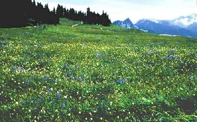
From the Visitors Center, it's 3 miles to the park entrance (where we cough up our $10), then another 15 miles to the top of Hurricane Ridge. We will probably do lunch at the Lodge up there, (they have 2 large picnic areas and a cafe). This is also where, weather permitting, we will do a little hiking (see info above).
Bring warm clothing (just in case) & comfy shoes for hiking. Also it's windy on the deck of the ferry and can be cool to some people when the wind chill is taken into account.
-- Big thanks to Chris E. for personally scouting out this trip for us
Meet at the Victoria Harbour Ferry Dock (for M.V. Coho)
You guys will have to work this one out for yourselves :-).
Here are some links, though, to gather some more info on the various ways to get from Victoria/Vancouver to Port Angeles (with your car):
Drive to Hurricane Ridge
When you unload from the ferry in Port Angeles, turn left on the street that runs along the waterfront (can't remember the name). Follow the road & eventually it turns to the right. You will soon see 2 stoplight intersections. Go past the 1st light, (Front Street/Westbound Hwy 101). At the next light, turn left (First Street/Eastbound Hwy 101. A Gull Gas Station will be on your left). Move over to the right lane and go down for about 1.5 - 2 miles. You will soon see a brown overhead sign for Hurricane Ridge/Visitors Center. When you soon see a BP gas station on the left, you will be approaching Race St. Turn right. Go up Race Street for approx. 2 miles until you soon start to see the signs for the Olympic National Park Visitors Center. This will be our meeting place.
There are also a few places on the waterfront if any of the Canadians want to do a currency exchange (I know... haha)
The "Other" Ferry Route :-)
Take I-5 South and get off at Highway 20 for Anacortes/Whidbey Island. Stay on Hwy 20. Turn left at Anacortes, drive past Oak Harbor and keep going until you get to Keystone for the Keystone/Port Townsend Ferry. The Keystone Ferry schedule looks like this: 7:45 am, 8:30, 9:15, 10:00, & 10:45. (allow for 30 minute crossing). Follow Hwy 20 to Discovery Bay, then turn right on Hwy 101 to Port Angeles.
Fares are $8 for car + driver and $1.80 for each passenger.
For those who will be doing this, you will want to be on the 10:00 am ferry. If you get on the 10:45 ferry, you will be in Port Townsend at 11:15 am and with another 70-90 minute drive, you are cutting it close.
FYI: Whatever you do, do not get on the Anacortes/San Juan Island Ferry unless you want to spend 3.5 hours just to get to Sidney, B.C. and then spend another $35 for the Victoria/Port Angeles Ferry. This would be a major time and money consumer.
| Maps |
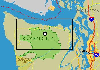 | 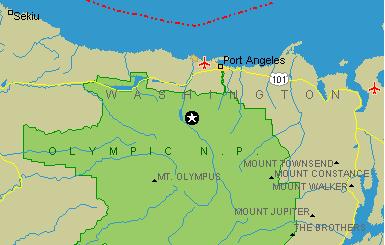 |
Hurricane Ridge Map (wide) | Hurricane Ridge Map (Zoom of Rectangle) |
| RSVP/Contact Info |
We would prefer to know who's coming to this meet via a quick RSVP to Keith H. but you can show up at the last minute if you want. Just don't be late or you'll be playing catchup most of the day. This includes the MR2 guys since we'd like to get an idea of parking space required and if we need to alter the final meet location.
For those who may need to find us, or for emergencies, you can contact Chris E. for his cell phone number. We'd rather not post it on a web page :-) In Port Angeles, his phone is not roaming or anything, so feel free.

Created: 8/06/98 by C. Jensen
Last Updated: 1/18/99
 Back to my home page....or goto the